Zero Deforestation Cocoa : how Kaoka can guarantee this to you ?
How is cocoa produced, and why it can be linked to deforestation? What role does deforestation play in accelerating climate change?
If you are reading these lines, there is a good chance that these environmental issues concern you as much as they concerns us. At Kaoka, a pioneering and militant organic fair trade chocolate company, these subjects are not just fleeting concerns: they have been shaping our actions for years.
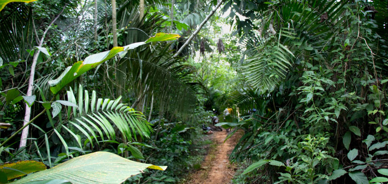
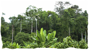
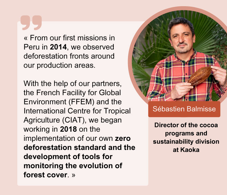
We have seen deforestation with our own eyes. By visiting the producing countries and talking with our partner growers. The situation is alarming. We know that behind the phenomenon of deforestation lies an economic necessity: forests are being cut down to enable population to cultivate the land and thus benefit from income to live.
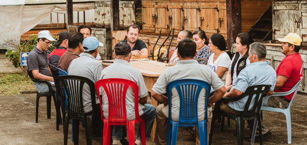
At Kaoka, as you may know, we do things differently: we have set up our own cocoa programs, by integrating the growers’ organisations into our operations. We have been working hand in hand with growers’ cooperatives for over 20 years.
Why are we telling you this? Because it is what allows us to get to know the realities on the ground, to exchange information on a daily basis with our growers partner organisations of and to set up long-term sustainable projects together.
Note Close relathionship allowed us to realize early on the scale of the deforestation problem. Without waiting for Europe to force us to react, we had taken the initiative and started working on our Zero Deforestation methodology long before the European regulations were introduced.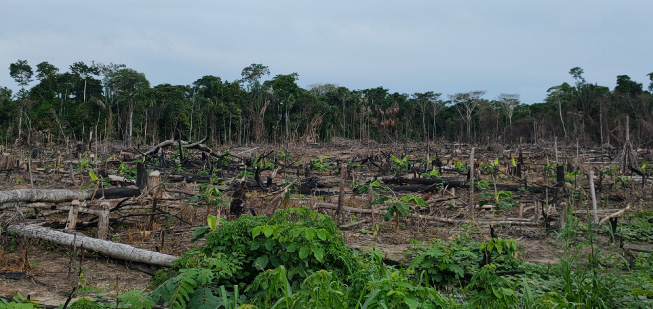
SUMMARY
- How do we at Kaoka ensure that our cocoa is truly deforestation-free?
- Better safe than sorry, isn’t it? When Kaoka promotes conservation cocoa farming
- Keep a close eye on the deforestation
How do we at Kaoka ensure that our cocoa is truly deforestation-free?
Proving that our cocoa, grown by nearly 5,000 families of growers, is not responsible for deforestation is not an easy task. To take up this challenge, we asked ourselves thousands of questions: how can we get growers to take part? What is a forest? How can we verify that our 5,000 partner growers are not cutting down their forests? How can we compensate for the fact that growers cannot expand their plantations? Which areas should be protected as a priority? etc.
To answer all these questions, we relied on our partner growers’ organisations and agroecology research organisations. Years of work and discussion have enabled us to develop a “zero deforestation methodology”. Made up of several stages, this methodology has become our roadmap: it guides us to guarantee you cocoa and chocolates that are deforestation-free.
1 – Risk analysis by country 🌎
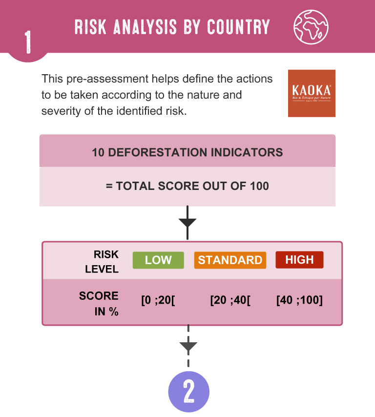
We work in countries with very different histories and agricultural contexts. In order to determine the risk of deforestation, it was important for us to establish the situation in each production country. Based on 10 deforestation indicators, this rating allows us to determine the level of risk of deforestation and thus adapt our actions in each country.
The 10 deforestation indicators used to evaluate the risk of deforestation in a country :
- What is the extent of forest coverage in the country?
- Are the forests under threat (already deforested or degraded)?
- Is there already a deforestation monitoring system in place in the country?
- Is the origin of the cocoa known, and how reliable is the information on this subject?
- How is the cocoa produced and how is the land used?
- Are local growers aware of the issues surrounding deforestation?
- Are local laws protecting the land (land law) being respected?
- Is the country of production taking measures against deforestation?
- Are local rules and laws being effectively respected?
- Are there certifications that promote good environmental practices?
Each criteria has a number of points that can vary between 4 and 22, depending on its importance. All these points are then added up to give an overall score out of 100.
If the country has between 0 and 19 points, we consider the risk to be low 🟢.
Between 20 and 39 points, we are talking about a standard risk 🟠.
And if the score climbs between 40 and 100 points, the risk is considered high. 🔴.
This country level risk analysis, is carry out to comply with European regulations. Whatever the result (low, standard or high risk), at Kaoka, we then systematically follow our full methodology.
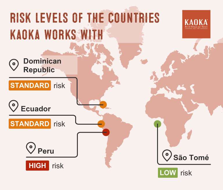
This risk analysis was done for the four countries with which we work:
- In São Tomé, the risk is considered low 🟢,
- In Ecuador and the Dominican Republic, the risk level is standard🟠,
- In Peru, the risk level is set to high🔴.
2 – Knowing our partner growers and their cocoa plots
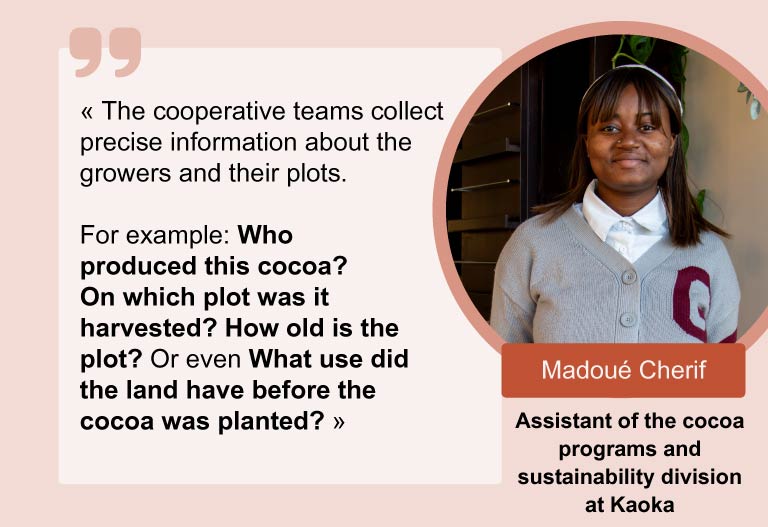
At Kaoka, we know each of our partner growers personally. However we lacked detailed information about their plots and their accurate mapping. To fill this gap our cooperative technicians visited each grower and together they used geolocation tools technology: GPS points were recorded to define the boundaries of each cocoa plot. These mapped areas are called ‘polygons’.
How are the polygons created?
Why is this geolocation step so important?
To find out whether or not our cocoa is responsible for deforestation, we need, above all, to:
- Knowing where it comes from: we must therefore be able to link each batch of cocoa produced to its plot of cultivation. In this way, we ensure and guarantee full and reliable traceability of our cocoa.
- To have precise knowledge of all existing cocoa production areas.
Collecting data in the field is a meticulous process that involves thousands of pieces of information. To make this task easier, we have equipped the co-operative teams with tablets and specially designed software to simplify data entry. For our three cocoa program partners in Ecuator, at São Tomé and in Peru, we have choosen the Trusty tool.
In Dominican Republic (the only cocoa program we didn’t create), our partners use their own tool to collect the data, before integrating it into our Trusty system, thus guaranteeing continuity and consistency in our traceability approach.
Note Trusty guarantees our internal traceability system: it is both verifiable and auditable, and allows us to ensure total transparency throughout the chain.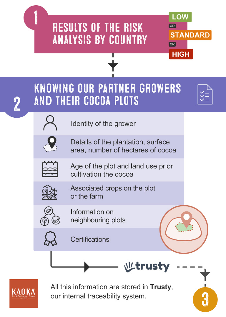
3- Focus on each cocoa plot 🔍👀
If we want to be sure that a cocoa was not responsible for deforestation, the first question we must ask ourselves is: In which plot or plantation was this cocoa grown in? What type of environment is it in? Was it a forest before?
We carry out an analysis of each plot to define its condition at a given moment (initial situation) in order to monitor its development in the years to come.
For this analysis, in Ecuador, Peru and the Dominican Republic, we use the model co-developed by CIAT and Kaoka. This model consists of five successive steps (in other words algorithmic models) thanks to the Open Source geographic software Quantum Gis.
In São Tomé, due to the insufficient quality of the satellite data, we opted for another model based on vegetation reflectance.
What is reflectance? Reflectance refers to the ability of a surface to reflect incident light. In geography and remote sensing, it is often measured by satellite at different wavelengths, allowing the analysis of plant composition and condition. To detect deforestation, the variations in reflectance are compared between images taken at different times. Healthy vegetation has a particular reflectance, but when it is cut down or destroyed (as in deforestation), these values change. Algorithms can therefore identify these changes and indicate areas where forest cover has been reduced.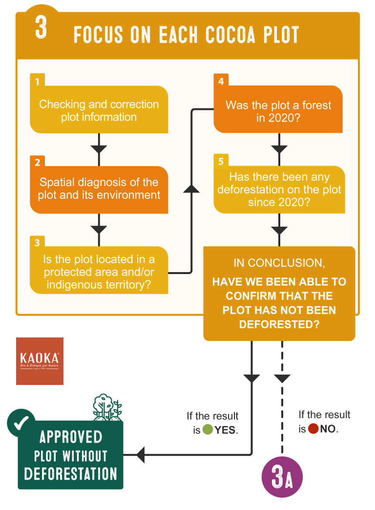
1. Checking and correction plot information 🧹
Before diving into the analysis, we make sure that the data collected by our teams in the field (see step 1) is accurate and well organized. Each plot is assigned a unique identifier, duplicates are eliminated, the coordinates of the peaks are verified, and if any polygons overlap, we manually correct the errors. A good working basis ensures reliable results!
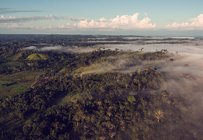
2. Spatial diagnosis of the plot and its environment 🛰️
Now, the cocoa production areas are being studied using satellite images. We don’t just look at the cocoa plot itself, but also at the 600 metres around it, to make sure we don’t miss anything. This security perimeter means we don’t overlook important elements: such as the presence of forests, deforestation, or even protected areas around the plot.
3. Presence of protected areas and/or indigenous territories 🌳
In this step, the model checks whether the plot is located in a protected area or indigenous territory.
- If yes, we proceed with the analysis of the plot in step 3A.
- If no, the search is extended to a radius of 2 kilometres around the protected or indigenous areas.
4. Presence or absence of forest 🌲🌲
To ensure that the plot is not located in areas previously classified as forests over a given period (between the 31 December 2020 and 2024), we have produced a 2020 map distinguishing forest areas from non-forest areas. To make it as accurate as possible, this map compiles several national and international data sources covering this period.
The algorithm then checks these elements:
- Were there any forests on the plot’s location in 2020?
- If the plot is located less than two kilometres from a protected area or indigenous reserve :
- Is there a forest within a 500 meter radius around the plot?
5. Presence or absence of deforestation 🌲❌
In the final step, the algorithm checks for the presence or absence of deforestation:
- Has deforestation been detected at the plot’s coordinates during the analysis period (2021-2024)?
- If the plot is located less than two kilometres from a protected area or indigenous reserve:
- Is deforestation visible within a 500 meter radius around the plot?
Results and conclusion of the of the initial plot analysis 🔍
In conclusion, have we been able to remove any doubt about deforestation on the plot?
- If the result is YES 🟢, the plot is approved without deforestation.
- If the result is NO 🔴, we move on to the next step (step 3A) to continue the analysis.
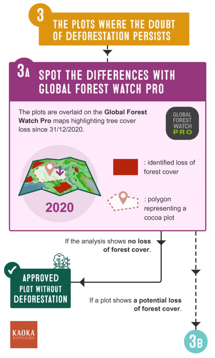
3A – Continue the investigation with Global Forest Watch Pro: spot the difference
If we have not been able to rule out the possibility of deforestation on a plot with certainty, nothing is left to chance: we conduct a more in-depth analysis. In concrete terms, we perform a ‘spot the difference’ exercise : we overlay the suspicious plot with maps showing the loss of forest cover since 31/12/2020, using Global Forest Watch Pro.
So, why 31/12/2020? 31 December 2020 has been chosen as the reference date, or ‘cut-off date’ in the EUDR. Companies must prove that their products do not come from supplies that contributed to deforestation or forest degradation after 31 December 2020.▶ Find out more about the European Regulation on Zero Imported Deforestation
The loss of forest cover is represented by coloured pixels on the Global Forest Watch Pro maps. If the analysis shows no loss of forest cover: the plot is approved 🟢. On the other hand, if a plot reveals a potential loss of forest cover, we proceed with step 3B.
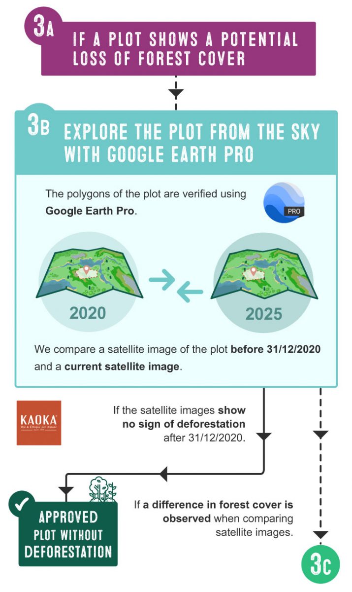
3B – Explore the plot from the sky with Google Earth Pro
If Global Forest Watch Pro reveals a loss of forest cover on a plot, we move on to a visual check, which means that we take a little height thanks to Google Earth Pro to ‘explore’ the plot from the sky.
We compare two satellite images: an old one, prior to 31/12/2020, and a more recent one, to see if the situation of the plantation and the forest has changed.
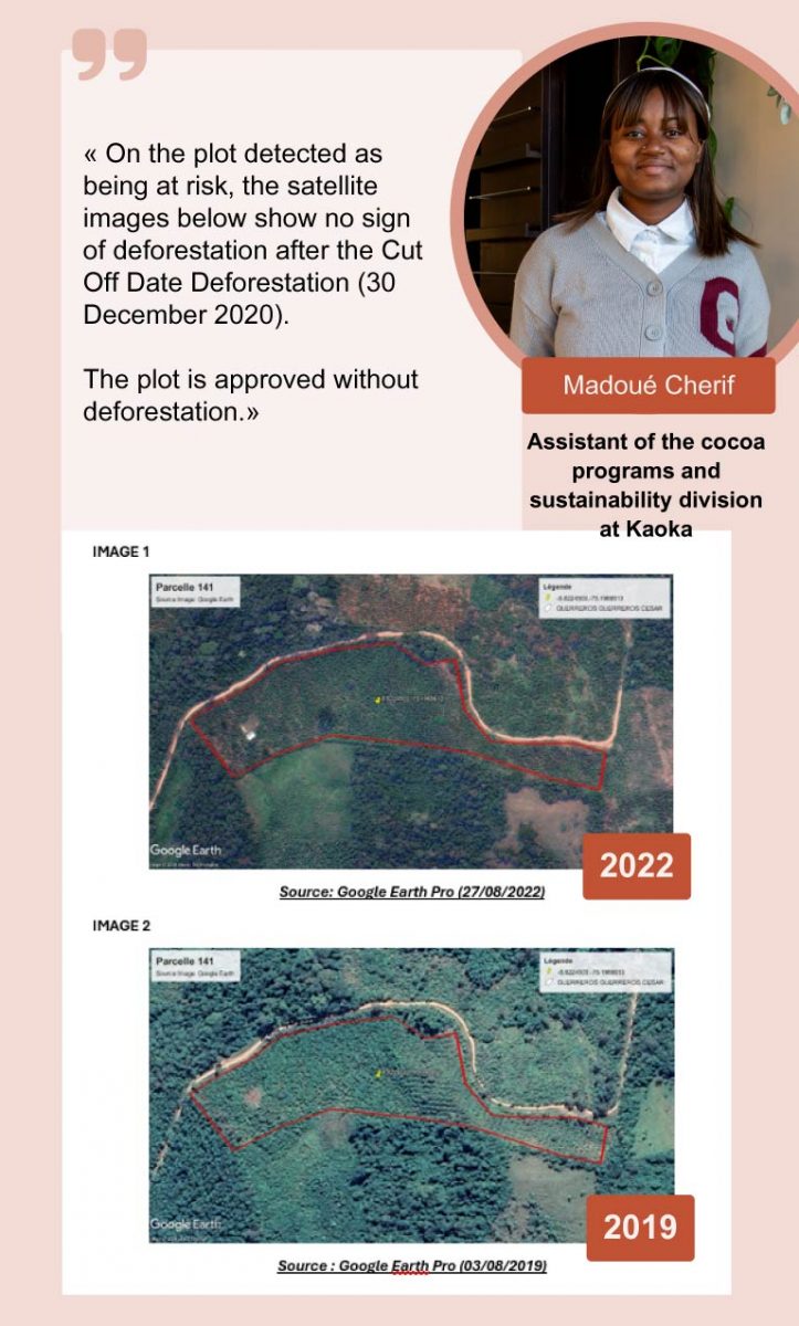
- If the satellite images show no sign of deforestation after 31/12/2020, the plot is approved without deforestation 🟢.
- If the satellite images are inaccurate and/or show a difference in forest cover, we move on to the final step.
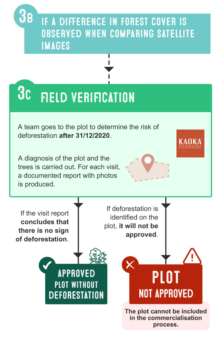
3C – Looking for clues: Field verification
In rare cases, satellite images prove insufficient and do not guarantee the total absence of deforestation. A team of technicians then goes to the site to assess the deforestation risk after 31/12/2020.
During this visit, the plot and its trees are carefully inspected. A detailed and documented report with photos is compiled at the end of each field visit.
- If the visit report concludes that there is no sign of deforestation, the plot is validated and considered as not deforested 🟢.
- On the other hand, if deforestation is identified on the plot, it cannot be approved. It is removed from the commercial perimeter and from the list of certified plots ⚠️.
Better safe than sorry, isn’t it? When Kaoka promotes conservation cocoa farming
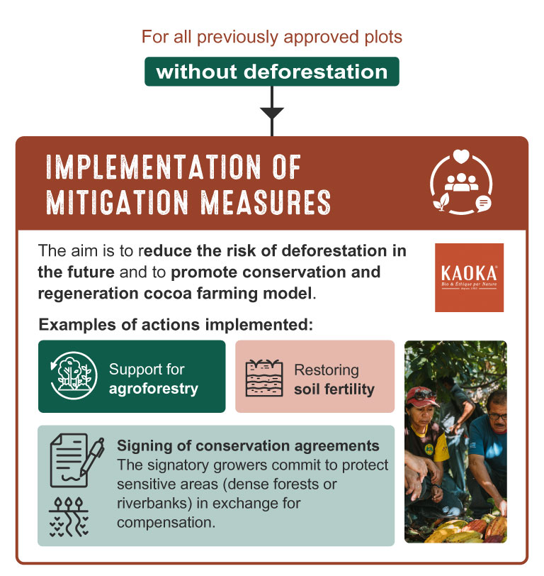
Keeping an eye on deforestation is already a very good thing, but making sure that it doesn’t happen in the future is even better! In all our cocoa programs : Ecuador, Peru, São Tomé and the Dominican Republic, we have implemented mitigation and regeneration measures. In other words, we are working hard to preserve existing forests.
What if we bring in new partner cooperatives? When we integrate new partner cooperatives, we follow the same methodology. Depending on the number of new partner growers, it can take us between 3 and 6 months of work!Kaoka’s role is to raise awareness and train willing growers to mitigate the risk of deforestation and promote conservation cocoa farming. It should be noted that our partner growers retain full ownership of their land and can manage it as they wished, as long as they respect local regulation.
Here are some of the actions we have implemented:
- Support the development and maintenance of agroforestry. For example, rehalibitation deforested areas through sustainable practices, such as sustainable timber harvest, which also provides additional income for growers.
- Restoring soil fertility.
- Sign conservation agreements with growers.
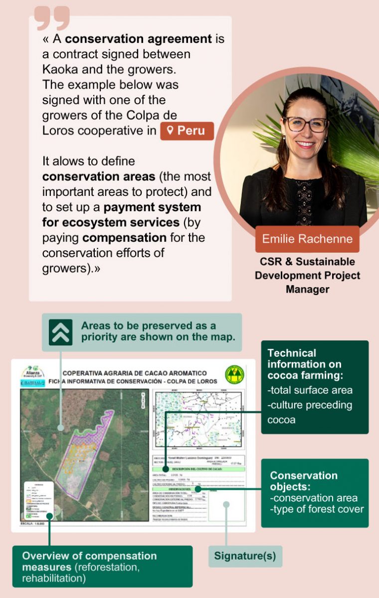
Why sign conservation agreements?
Thanks to research conducted by agroecology experts, we have been able to identify the most important areas to preserve, such as dense forests or riverbanks. This research has led the proposal of conservation agreements to growers. In exchange for ecosystem services and/or compensation (such as organic fertilisers, reforestation or rehabilitation programmes), they undertake to protecting and enhancing local forests.
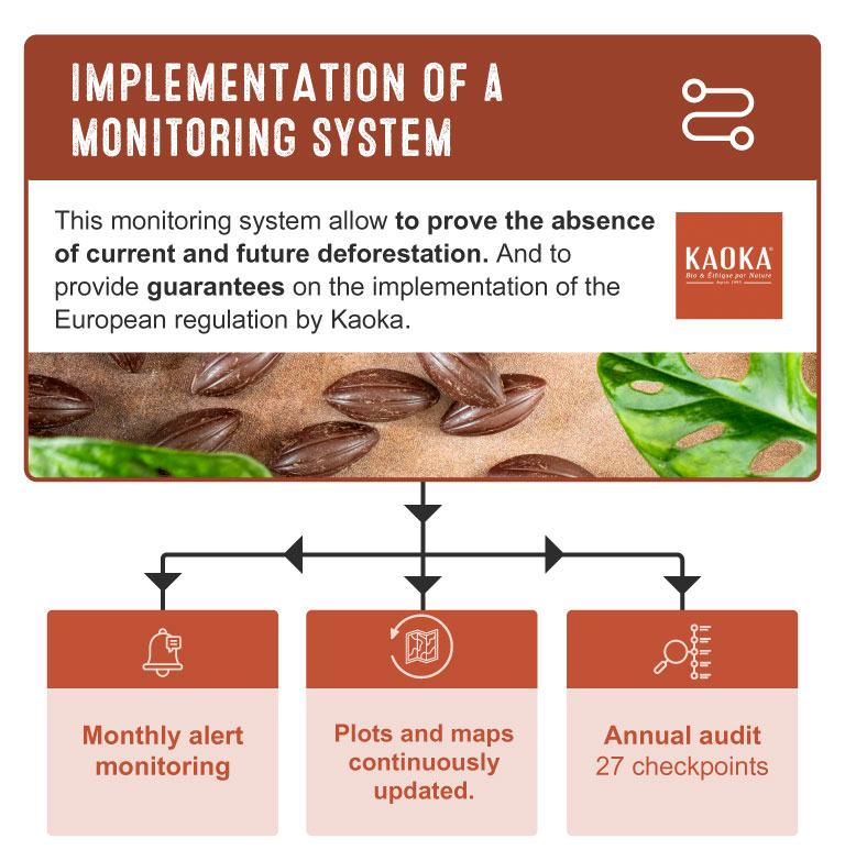
Keep a close eye on the deforestation
We have ensured that our cocoa is not produced on deforested land (after 31 December 2020). From now on, we must remain vigilant to ensure that our partner growers’ plantations do not expand at the expense of forests.
To achieve this, we have set up a monitoring system that allows us to certify the absence of current and future deforestation. It allows us to prove how Kaoka respects and implements the future European regulation (without cheating!).
- Monthly alert monitoring 🚨🌳
Every month, if a risk of deforestation is identified, we receive alerts. As soon as we receive an alert, we start gathering informations. And if necessary, we don’t hesitate to go to the plot concerned to check with our own eyes. - Continuons updating of plots and maps. 🛰️
In order to closely monitor the evolution of deforestation, the maps are automatically updated in real time, and before integrating a new grower into a cooperative with which we work, their plots are integrated into our system and analysed. - Annual audit🔍📊
An audit is carried out every year: 27 checkpoints are thoroughly verified.
A last word
We are proud to have transparently shared our Zero Deforestation methodology with you.
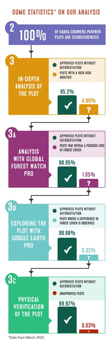
To date*, we have registered several thousand cocoa production plots in our Trusty tool. In order to better understand how the analysis results are assigned to the various stages of our methodology, here are some statistics clues:
- After step 3 – the in-depth analysis of the plot, 95.2% of the plots have been validated, while only 4.80% require further analysis in step 3A.
- At the end of step 3A – Analysis with Global Forest Watch Pro, 98.85% of the plots are validated as zero deforestation, and 1.05% indicate a possible loss of forest cover.
- After step 3B – Exploration with Google Earth Pro, 99.68% of the plots are approved without deforestation, and 0.32% require field verification.
- Finally, after step 3C – Physical verification of the plot, 99.97% of the plots are approved as having zero deforestation, while only 0.03% are excluded from the commercialisation program.
*March 2025
We hope that this article has given you a better understanding of the Zero Deforestation methodology of Kaoka and our commitment to ensuring that our cocoa is not responsible for deforestation.
If you have any questions or would like more information, you can send us your questions using our contact form. We look forward to hearing from you!